
Easements are one of the most misunderstood and frequently overlooked parts of property ownership in New South Wales. In areas like Lake Macquarie, Newcastle, and the Central Coast, easements are common due to older subdivisions, shared driveways, drainage corridors, and utility infrastructure. When they are not clearly understood, they often lead to disputes, construction delays, or costly compliance issues.
Easement surveys in NSW provide clarity. It identifies exactly where legal access rights exist, how they apply to your land, and what restrictions or obligations come with them. Whether you are buying, building, subdividing, or resolving a disagreement with a neighbour, an easement survey protects your property rights and helps you make informed decisions with confidence.
What Is an Easement and Why Is It Important?
An easement is a legal right that allows another party to use part of your land for a specific purpose. Common easements include driveway access to a rear lot, drainage or sewer infrastructure, stormwater flow paths, and electricity or communications services.
Easements are registered on the property title and remain in place even when land ownership changes. While they appear on deposited plans, their physical location on the ground is often unclear, especially on older properties where fences, driveways, or structures may not align with original survey data.
If an easement is misunderstood or ignored, property owners risk building over it, restricting lawful access, or breaching council and utility authority requirements. This is where an easement survey becomes essential.
What Is an Easement Survey?
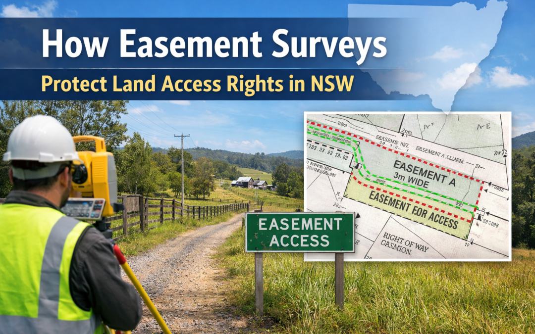
An easement survey is a cadastral survey that defines the exact location, width, and alignment of easements in relation to property boundaries and existing improvements. It involves detailed research of title documents and deposited plans, followed by precise on-site measurements to translate legal information into real-world positions.
The final survey plan shows how easements sit relative to fences, buildings, driveways, and other features. This allows property owners, designers, and builders to clearly understand what can and cannot be done on the land.
Easement surveys are commonly completed alongside a boundary survey, particularly where property lines are unclear or when work is proposed near a boundary. You can read more about boundary surveys here:
What Is a Boundary Survey? A Simple Guide for Lake Macquarie & Newcastle Property Owners
How Easement Surveys Protect Land Access Rights
For many properties, especially battle-axe blocks and rear lots, legal access depends entirely on an easement across neighbouring land. An easement survey confirms that this access exists and shows precisely where it runs.
This protects your right to use the access without obstruction and ensures neighbouring owners understand the limits of that right. It also prevents accidental encroachment, such as fencing, landscaping, or construction that blocks or narrows the easement.
In the event of a dispute, a registered survey plan prepared by a qualified surveyor provides objective, evidence-based clarity. In many cases, this resolves disagreements early and avoids escalation to legal proceedings.
When Do You Need an Easement Survey?
An easement survey is recommended whenever you are planning work that could affect access, services, or drainage on your property. This includes new construction, driveway works, fencing, retaining walls, or landscaping near an easement.
It is also essential during property purchases, particularly where access is shared or not obvious on site. Many buyers only discover easement issues after settlement, when changes or approvals are blocked.
For land subdivision, easements must be accurately defined and shown on subdivision plans submitted to council and NSW Land Registry Services. Subdivision approvals often rely on easements to provide lawful access and service connections to new lots. More information is available here:
How to Subdivide Land in NSW: A Simple Guide for Lake Macquarie & Newcastle Property Owners
Easement Surveys and Development Compliance in NSW
Councils across NSW, including Lake Macquarie City Council and Central Coast Council, regularly require survey confirmation of easement locations as part of development approvals. Building over or interfering with an easement without approval can result in stop-work orders or forced removal of structures.
An easement survey allows architects, engineers, and builders to design with certainty from the outset. It is commonly used alongside peg-out surveys to ensure structures are set out correctly and remain clear of easement areas.
Why Local Surveying Knowledge Matters
Easement interpretation in NSW is governed by legislation, surveying standards, and long-established cadastral principles. Local conditions also play a major role. In Lake Macquarie and coastal regions, drainage and sewer easements are particularly common due to terrain, flood management, and historical infrastructure layouts.
Working with a local surveyor who understands council requirements, historical survey records, and regional conditions ensures easements are interpreted correctly and practically, not just theoretically.
For a broader explanation of why surveying is critical to property ownership, visit:
What Is Land Surveying? A Guide for NSW Property Owners
Authoritative NSW Reference
Official guidance on easements, land titles, and property dealings is available from NSW Land Registry Services.
Frequently Asked Questions About Easement Surveys
What is the difference between a boundary survey and an easement survey?
A boundary survey defines property boundaries, while an easement survey identifies legal rights that exist within or across those boundaries. They are often completed together for full clarity.
Can I build over an easement in NSW?
In most cases, no. Building over an easement usually requires formal approval from the benefiting authority and is often prohibited.
How do I know if my property has an easement?
Easements are shown on the property title and deposited plan, but a survey is often required to confirm their exact position on the ground.
Are easement disputes common?
Yes. Many disputes arise simply because the easement location or width is unclear to one or both parties.
Do easements affect property value?
They can, depending on location and impact on land use. Clear surveys reduce uncertainty for buyers and lenders.
Is an easement survey required for subdivision?
Yes. Easements must be clearly defined and shown on subdivision plans submitted for council approval.
Can easements be removed or relocated?
Sometimes, it requires legal processes, approvals, and new survey plans. A surveyor can advise on feasibility.
How long does an easement survey take?
Timeframes depend on site complexity and available records, but most residential easement surveys are completed efficiently once information is obtained.
Who can carry out an easement survey in NSW?
Only a suitably qualified and registered surveyor can legally define and certify easement locations.
Talk to a Local Surveyor About Your Easement
If you own property in Lake Macquarie, Newcastle, the Central Coast, or surrounding NSW regions and need clarity around easements, access rights, or development constraints, MJM Surveying can help.
We provide clear, evidence-based easement and boundary surveys that protect your property rights and keep your project compliant.
Contact MJM Surveying today to request a quote or discuss your site with a local expert.